

I have often written about my interest in regionally specific architecture, especially vernacular forms that derive from local climatic conditions or materials availability. I recently spent some time in the Florida Keys and in my typically geeky architecture fashion, spent almost as much time looking at the local historic buildings as I did relaxing on the beach.
New Urbanism, 19th century style, Old Louisville

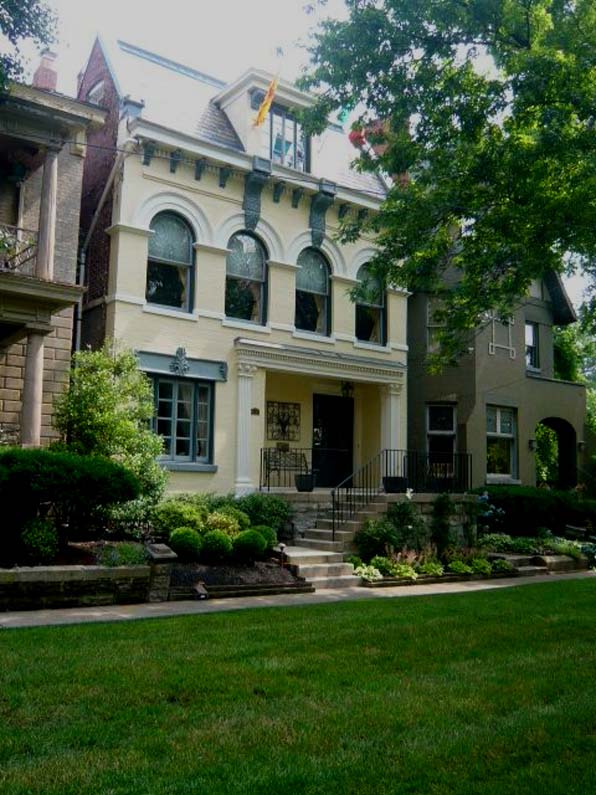
house in Old Louisville, Belgravia court
"New" urbanism has been criticized enough for its slightly ridiculous and myopic name. It seems that New Urbanism has now transitioned from an innovative design process to make walkable, more sustainable cities, to a buzz word bandied about by developers to pack more units and more density into even smaller acreage. I live in a New Urbanist kind of neighborhood that I quite enjoy even if the mix of residential and retail is a bit light on the shops and restaurants.
On a recent trip to my hometown of Louisville, Kentucky, I took an opportunity to head downtown to the Old Louisville section of town. I wrote about this previously in terms of its formation and history, but what really struck me this time were the small pedestrian-access only areas - a series of green lanes and squares which fronted the houses. And what impressed me the most was how gracious and carefully delineated each of these areas have become. Certainly the passage of time - these areas are now 100 years old - have eased and softened some edges lending a composed, relaxed air to the formality of the building designs. But it is the apparently simple things, like the distance between houses, the width of the lanes, the slightly veiled gates to gardens beyond, that are so impressive, carefully handled and now governed with a loving stewardship.
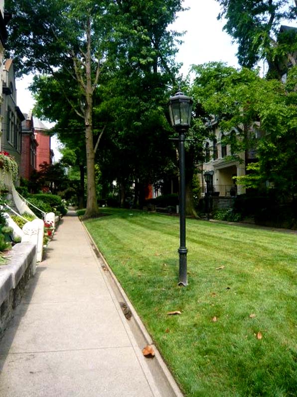
access to fronts of houses, pedestrian walk, Old Louisville
There was a time when all of Old Louisville, and certainly these pedestrian access lanes, was not so nice or well-loved. Like most of the U.S., urban flight abandoned downtown residential districts and many of the suffered. These houses which did not sit facing normative streets paid a particularly steep price, being cut up into so many apartments because the auto-centric culture did not value the density or access.
OL house 01
Luckily these well-built structures survived that time, both due to the quality of the architecture and planning, and most likely, because no developer or urban renewal agency had their eye on this part of town. This district, the Old Louisville Historic District was quickly formed in the 1970's to fend off some of those early demolishing threats and because of those efforts we not only have a section of beautiful, delightful residential housing, but a remarkable demonstration of old New Urbanism.
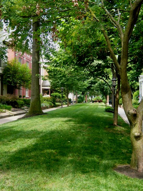
lawn1
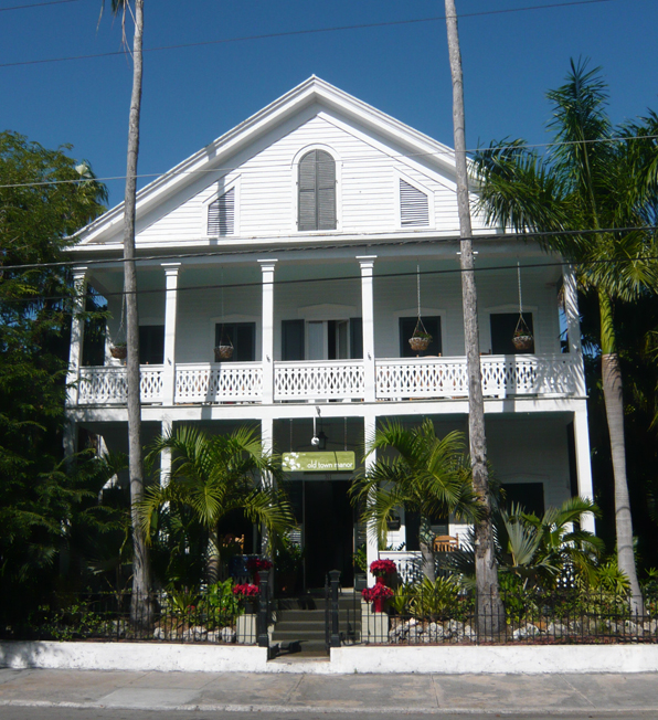
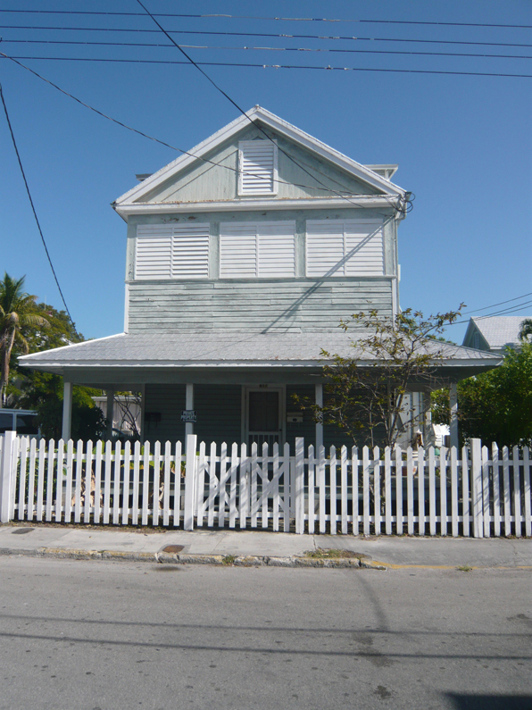
Regional architecture - Florida Keys, by Boulder architects M. Gerwing Architects
Keys5
I have often written about my interest in regionally specific architecture, especially vernacular forms that derive from local climatic conditions or materials availability. I recently spent some time in the Florida Keys and in my typically geeky architecture fashion, spent almost as much time looking at the local historic buildings as I did relaxing on the beach.

Keys4
Like any relatively isolated region, the architecture of the Keys, and especially Key West, is dominated by its largest growth period, starting with the late Victorian era and extending to the Depression. As a result, the typologies of houses you find are almost exclusively wood-framed, simply-gabled homes with painted lap siding and more-or-less overly wrought scroll details. While there are plenty of houses from other periods, these basic vernacular houses became the standard that has been replicated, often less successfully. The funky mid-century commercial architecture of the Keys, including the building-as-sign googly constructions date from the 1950's and 60's when the Overseas Highway surplanted the train and boat as the dominant mode of access to the Keys, are more often found at the beginning of the island chain, closer to Key Largo.
Keys1
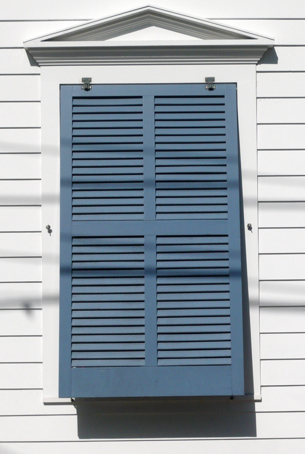
As in so many older sea-faring communities, the predominance of horizontal wood siding reminds one of the hulls of boats and the gable-fronted houses resemble so many upturned boats. Of particular interest to me are the use of shutters and porches to mitigate the harsh Caribbean sun while still allowing ample breezes to move through the structures. Unlike Italian house shutters, the Keys shutters are plantation style, often not individually operable but top-hung as a panel that can kick out at the bottom.
Keys2
Of course here in the Keys, the shutters do not just provide sun control, but are necessary protections for the Gulf storms and occasional hurricane. For that reason they can be found on doors and windows within porches, well beyond the areas where sun shading would be necessary. These shutters provide a kind of vertical emphasis to the buildings that contrasts with the predominant horizontal siding and decorative rails. The overall effect is of a lightly sprung craft, held in tension, that takes the kind of maintenance and attention that only a boat-owner could appreciate.
Keys3
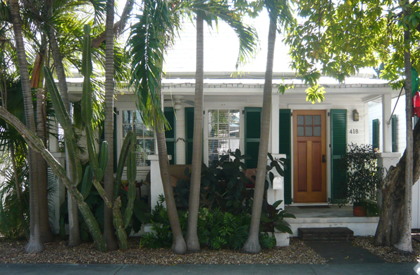
The older portions of Key West are also fairly urban and dense, with house fronts mere steps from public sidewalks. The shutters are also used to create privacy while keeping doors and windows open. As in the photo above, the subtle delineation of public and private spaces, from sidewalk to private walk to porch to interior, works in about ten feet of space, each layer carefully playing its role.
This kind of attention to the details of public and private space are often lumped into the concepts of New Urbanism. But, as you can see, some good old fashioned urbanism is successfully at work, design solutions worked out over years of lived experience that architects would do well to study. And shutters that actually work, not just applique patterns, a fearful architect's pet peeve.
by Boulder architects M. Gerwing Architects
neighborhoods
About a week ago I moved from far south Boulder to far north Boulder. Not a great distance, but a big change. Most mornings I walk or run with my dog for about 3 miles. In south Boulder that meant a meandering course through a never-ending succession of suburban tract houses on winding streets to a small lake and then back. In north Boulder, on the ragged edge of town, the same distance is quite different, in a land with variable zoning and development over many years for many uses.
Starting in our little New Urbanist neighborhood of "mountain Victorian" houses and condos, we travel first past

and even more dense neighborhood, down-right urban in feel, of three-story masonry buildings with residential units above commercial spaces below and then along a creek to a trailer park with its chaotic arrangement of streets and fences. That trailer park gives way to

an open space buffer of tall grasses with magnificent views of the foothills just west of Boulder to

another neighborhood of little houses and courtyards, along a paved open-space path. After a brief sojourn into the dog park, we make our way north through the open space past a few blocks of large, single-family houses in the typical suburban, detached, wide-lawn arrangement.

Our next change of scene takes us past some small warehouses and the city's lost bicycle depot and then

the oddest collection of buildings - a Holiday Inn Express, the domed storage building of the Transportation Dept and the now-abandoned fire department training tower. From there it gets maybe stranger still as we pass

the National Guard site with its collection of buildings and fighting vehicles which is across the street from the non-profit low-income housing organization and a series of more sheet metal warehouses and garages. The sheet-metal-shed tour continues as we move

along by the organic peat moss provider, the warehouse strip that contains a dry cleaner, winery and floor finishers, and ends with the kid's fun park.

And then back again to the Holiday neighborhood of new urbanist houses and condos surrounding little courtyards, founded on the site of the former Holiday drive-in movie theaters.
There are sections of this walk that are undeniably scrubby. But the vibrancy of all this disorganized flotsam is interesting and makes my small new section of town feel like a city. And, like nature, the most interesting and vibrant life is found at the edges.
New technology and the richness of history
I have been thinking a lot about how to better harness new technology and new media resources to bolster interest in historic preservation and the changing architectural faces of our cities. I have written before about the potential of posting QR codes that allow visitors to easily access a rich and deep array of information that a typical sign can not accommodate. This has now been taken into the real world application of a building in Tokyo that displays QR codes on its facade that can be read by a smartphone and that accesses the building users Twitter feeds in real-time.

I have been very impressed with some recent augmented reality apps, like Sara, that allow you to use your smartphone and its camera and gps technologies to envision a proposed building on a site. By downloading the app you can simply point your smartphone like a camera at a specific location and along with the actual building or site that you are seeing, an image of a future project from the same vantage point will appear on your phone's screen.

I have yet to find someone that has applied this technology to envisioning the history of a city. You may have seen the history slider in Google Earth's satellite imagery that lets you scroll through historical aerial images of a city and gives a great understanding of the incremental development of a given place. If the 3D buildings in Google Earth were tagged with their date of construction, you could do the same with the 3d imagery, scrolling through the decades, watching buildings rise and fall and new construction rise again. I think this would be an amazing resource and break the veil of history that often impedes our understanding of time and place. It is so very difficult for folks to believe that the buildings and spaces around them have not always been that way. We all know this intellectually, but without visible evidence of previous eras it is impossible to really inhabit the city through time.

Beyond this capability in Google Earth, I would like a developed app that would integrate all those freely sourced 3D buildings built online and place them within an augmented reality app. Anywhere you walk through the city you could enable the app and hold up the phone and from the same vantage point, be able to scroll through hundreds of years of urban growth and transformation. The perspective on current projects that that kind of a technology would engender would radically change both architects and the public view of what our places have been and will be.
Locally there are two programs that begin to approach this kind of real time/place historical understanding using current tools. Historic Denver's Denver Story Trek allows people to choose from a range of designed tours or the ability to create your own. As you walk, bike or drive around the city, a text message prompts you to information about a given site, both its architecture and social history. Free audio files can accompany your tour and help bring to life each site.

Another program, run by the Denver Public Library's Western History & Genealogy folks, called Creating Communities, harnesses a vast digitized archive of images and information to map neighborhood histories. Their work consists of a Google map containing building histories and an iPhone app, Creating Communities, that allow you to search your neighborhood and access information about its city while also on the move.
Can we expect to see my proposed app some time soon? Well, there's not much money to be made in preservation, so unless there's so nice grant out there for a pilot project, probably not. If you know of such a thing, let me know. If you have further thoughts on how to apply this technology to architecture and preservation issues, I would love to hear that as well.