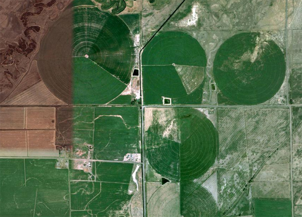
On a recent trip to the San Luis Valley, I took along a map, my phone's GPS, and a couple of satellite images. From that elevated perspective, the Valley is a playground of geometry. The large circles of center pivot irrigation fields overlays with the strict orthagonal grid of roads creating an ordered and rational allocation of property and access.

The image above, a satellite image, is split with two different seasons stitched together depicting the color and growth of irrigated fields - late fall on the left, spring on the right.
The map above shows the strict delineation of space in a grid, not unlike a typical city plan.
However, on the ground, things are much different. It is almost impossible, especially at 65mph, to perceive the circular irrigated fields. These figures, so dramatic from satellite images, are so large that the foreshortening of perspective makes their perception on the flat plane of the land almost impossible.
The same can be said for the grid of roads. Driving the dusty gravel roads it is clear that almost every intersection is a four-way, 90 degree construction, but the overall impression of a large grid laid over the landscape is imperceptible. A hint of this is found in the difference between the road map and the satellite image. The image below is the same area as the gridded road map above. So although the grid's east-west and north-south aspect ratio may remain consistent, the nature of the earth changes quite dramatically across the same territory.
It is the very flatness of the land, surrounded by dramatic, snow-covered peaks, that so dominates your vision. It is true that "map is not the territory" of course, but in this case the satellite image is not the same kind of abstraction as the road map. The satellite image is a photograph of the reality, but so is the image below.
The map tells us where things are in relation to each other, but not how they are. The satellite image fills that in a bit, but only a small bit.


