

after almost a week of unprecendented rains, flooding has surged all over the Front Range in Colorado. In a usually dry season, we have had more than 14 inches of rain in 2 days (that is about 2 years worth of rain here in the arid West).
Most Front Range communities sit on the edge of the fold where the relatively flat plains abruptly tilt up to start the Rocky Mountains. And, of course, these settlements founded themselves at water sources - snow-fed creeks that stream down from the mountains, gathering a reverse delta of little feeder streams, into a single, larger stream of river that spills out on to the plains. As we get very little rain out here, these streams are most active in May when the high mountain snow melt is most rapid. Little riverlets that are dry for most of the year swell to raging courses. As this happens every Spring and snow fall amounts don't vary all that much year to year, small flood plains or open areas surround these streams as they run through town. Once in a great while a particularly large snow melt will break the banks and cause some flooding and erosion.

Boulder Flood map 01
The urban form that has built up around these little streams was in no way prepared for the onslaught of 14" of rain in September. Houses and businesses within a block or two of each of these water courses were overwhelmed with rapidly flowing mud and water. The debris flow was made worse by the recent wildfires, denuding the landscape and making topsoil up in the mountains even more fragile to erosion. The small branch that runs near my place is usually dry in September and the underpass is there more for pedestrian and bike access than to act as a floodway.
I write this as I am sitting in my office looking north, watching yet more rain soak the city. The worse is probably over according to the weather experts. The town is full of pickup trucks carting off soaked carpet and ruined furniture. The radio is announcing yet another flash flood warning for much of the Front Range.

map_boulder_floodplains-1-201304171217
Of course we can design buildings and landscapes to minimize the impacts of flooding. The City's website has always had very good information on the locations of flood prone areas - the 100-year flood zone, the conveyance zone, etc. But none of these maps imagined so much rain that flowed so quickly down every slope that even houses on the edge of mesas, far above flood zones, were heavily impacted by downhill debris flows and more water than sump pits and drain tile can handle.
So what to do next? Design for the worst-case? Certainly that should be the direction for the houses along isolated creeks and steep canyons west of town where the loss of life is at stake. But down here in the city, do we trade off some occasional water damage to basements against the chance of frequency of 100-year events?
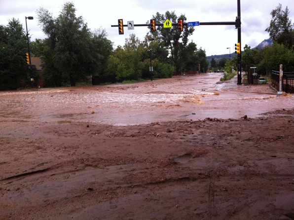
Broadway and Iris, Boulder flood
I wrote some posts a couple of years ago about the risks of wildfire in the arid West. And now we are not so arid for at least a week or so. And the same topography that makes fires so dangerous - the steepness and remoteness of roads, the deep folds between peaks and valleys - creates as much threat for flood as fire.
We design houses to resist falling, burning embers drifting down from the sky. We design houses to resist storm-driven debris flows and water seeping up from below. We live in the fragile middle.